


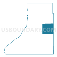
Clifton Twp. Voting District, Traverse County, Minnesota
About
Outline

Summary
| Unique Area Identifier | 604668 |
| Name | Clifton Twp. Voting District |
| County | Traverse County |
| State | Minnesota |
| Area (square miles) | 38.31 |
| Land Area (square miles) | 38.31 |
| Water Area (square miles) | 0.00 |
| % of Land Area | 100.00 |
| % of Water Area | 0.00 |
| Latitude of the Internal Point | 45.80286610 |
| Longtitude of the Internal Point | -96.32013920 |
Maps

Graphs
Select a template below for downloading or customizing gragh for Clifton Twp. Voting District, Traverse County, Minnesota


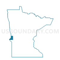
Neighbors
Neighoring Voting District (by Name) Neighboring Voting District on the Map
- Croke Twp. Voting District, Traverse County, MN
- Dollymount Twp. Voting District, Traverse County, MN
- Eldorado Twp. Voting District, Stevens County, MN
- Gorton Twp. Voting District, Grant County, MN
- Lake Valley Twp. Voting District, Traverse County, MN
- Logan Twp. Voting District, Grant County, MN
- Monson Twp. Voting District, Traverse County, MN
- Redpath Twp. Voting District, Traverse County, MN
Top 10 Neighboring County Subdivision (by Population) Neighboring County Subdivision on the Map
- Lake Valley township, Traverse County, MN (237)
- Monson township, Traverse County, MN (133)
- Eldorado township, Stevens County, MN (94)
- Logan township, Grant County, MN (93)
- Dollymount township, Traverse County, MN (77)
- Clifton township, Traverse County, MN (75)
- Croke township, Traverse County, MN (75)
- Gorton township, Grant County, MN (49)
- Redpath township, Traverse County, MN (48)
Top 10 Neighboring Unified School District (by Population) Neighboring Unified School District on the Map
Top 10 Neighboring State Legislative District Lower Chamber (by Population) Neighboring State Legislative District Lower Chamber on the Map
Top 10 Neighboring State Legislative District Upper Chamber (by Population) Neighboring State Legislative District Upper Chamber on the Map
Top 10 Neighboring 111th Congressional District (by Population) Neighboring 111th Congressional District on the Map
Top 10 Neighboring Census Tract (by Population) Neighboring Census Tract on the Map
- Census Tract 702, Grant County, MN (2,926)
- Census Tract 4801, Stevens County, MN (2,426)
- Census Tract 4601, Traverse County, MN (2,116)
- Census Tract 4602, Traverse County, MN (1,442)